If you visit the St Giles Hill Overlook that looks west across the city of Winchester, you might notice a cubic stone block to the left of the viewing platform. The cube has a circular brass dial on top and is set in a “playpen”. The top surface of the stone is engraved with altitude, Latitude, and longitude, now difficult to see now as it has been weathered.

Directional dial at the overlook.
The brass plate is a directional dial with lines radiating out from a common origin (the viewing platform) and pointing to key locations in the city. The plate also has the following word engraving on it – “ St Giles Hill – The great fair of St Giles granted to Bishop Walkelye by William Rufus was held in September for several centuries.
On this spot Waltheof the last Saxon earl was executed on the 31 May 1076 by order of the conqueror.” – see photo below.

Inscription to the St Giles Hill Fair and Earl Waltheof.
The plaque refers to the fair that was held on St Giles Hill each year for several centuries and is mentioned elsewhere on this website. Bishop Walkelye (Walkelin) was the first of the Norman bishops of Winchester. Earl Waltheof was the son of a Saxon Northumbrian Earl. Waltheof was married to Judith the niece of William the conqueror. After taking part in a couple of conspiracies against the king he was executed. Apparently, he was popular with the people so the execution was carried out early in the morning away from the city. The place of his execution was one marked but apparently was lost. It is not known if the inscription on the dial marks the real position of the execution. So when was the directional dial placed in position?
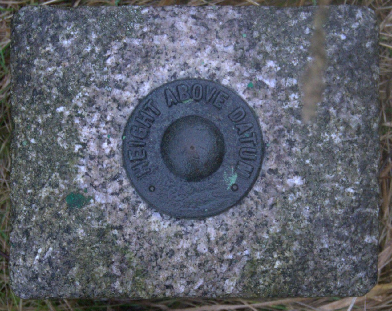
At first sight, the stone block looks like an Ordinance Survey (OS) Fundamental Benchmark (FBM) used for calibrating topographic heights when map surveying. If this were the case it could be calibrated from records, however, no record of it can be found on the OS Benchmark database.
A closer look at the Overlook block shows that it does not follow the standard FBM construction and is not labeled as Ordinance Survey as would be expected.
Top view of FBM
The visible section of an FBM pillar (in this case made of granite) is usually about 21cm by 28cm and around 30cm tall, with a brass bolt set into the top and a nameplate declaring it to be an ‘Ordnance Survey BM’. There is also an underground chamber with contains the “master” or precise reference mark for the point.

A typical plaque identifying the structure as OS.
For more information about Ordinance Survey Benchmarks around St Giles Hill see Ordinance Survey Benchmarks what are they and what have they got to do with St Giles Hill.
Although the Direction Dial records Latitude/longitude and altitude it was not used for mapping by OS. It was probably put in place in the early 1930s.
An approximate date can be deduced from looking at OS maps. The 1931 25-inch OS map of the area does not show a directional dial at the location, it first appears on the 1939 update.

A small area of the Winchester OS 25-inch map published in 1932 (revised 1931) showing St Giles Hill. Note there is no directional dial.

A small area of the Winchester OS 25-inch map published in 1939 (revised 1937/8) showing St Giles Hill. Note the addition of the directional dial.
A further indication of the approximate age is given by the brass dial itself. Amongst the locations indicated on the dial is the Winchester Lido which was designed and built in the early 1930s by Charles Schwedth.
Below is a photo of part of the brass directional dial plate showing the direction to the Winchester Lido.

Photo of part of the brass directional dial plate showing the direction to the Winchester Lido.